 image by Francis Quigley (www.RiverHousePhoto.com)
Showing posts with label walking. Show all posts
Showing posts with label walking. Show all posts
Tuesday, June 2, 2009
Comeragh Mountain Traverse
image by Francis Quigley (www.RiverHousePhoto.com)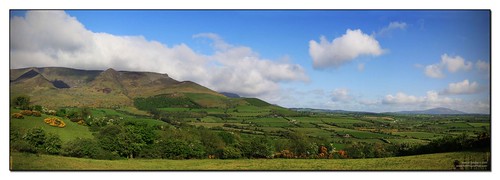
This is a 7 mile walk which would take a good walker in the region of 5hrs. It starts at the West side of the Comeragh mountains near Knockanafrin and finshes at Kilclonney Wood. The route is not marked but the map and full GPS route are available at the link below.


Friday, May 29, 2009
Rath Beag Loop Walk

Rath Beag Loop
Directions Directions to Trailhead
From the village of Rathgormack on the R678, follow the R678 in the direction of Clonmel. After a 5km straight stretch, the road swing left and passes a downhill roadway on the right (the trailhead for the Glenpatrick Loop is down there). Shortly afterwards the road turns right at a 4-roadway junction – turn left onto a forestry roadway. Travel for 500m to reach the trailhead.
Ascent 340m/100m
Distance 4km
Estimated Time 1hr - 1hr 15mins
Grade Easy
Minimum Gear Trekking shoes, raingear and fluid
Services Rathgormack 6km, Clonmel 12km
Terrain Forestry roads
Theme Nature
Trailhead Entrance to Glenpatrick Woods, Co Tipperary
OS Sheet 75, S285 180
The loop is situated in the Rathgormack area of Co. Waterford, it is the shorter of two loops. Most of the friendly inhabitants are engaged in agriculture - producing milk, beef, lamb, wool, bacon, cereals and timber. Major social interests of the area include Gaelic Football and Hurling – and are the popular topic of conversation at the two Kennedy’s Pubs in the small village. Hollywood legend Stanley Kubrick filmed some of the outdoor scenes for the 1976 Academy Award-winning film, Barry Lyndon (starring Ryan O’Neal and Leonard Rossiter) in the area. Rathgormack is an area rich in history – such as the Mothel Abbey which was the home for hundreds of years to Augustinian monks whose abbot controlled a large tract of mid-Waterford until Henry VIII imposed English rule over the county. Rathgormack’s most famous “son” has to be the Highwayman, William Crotty who lived here in the early 18th century when Ireland was under British rule. The scenery is dominated by the Comeragh mountain range with a great mix of mountain features that includes the long and precipitous Knockanaffrin Ridge, the shadowy depths and glacial amphitheatre of Coumshingaun, the magnificent plateau and falls in Coum Mahon. Tourism to the area is becoming more popular and Rathgormack now has a Hiking Centre which can accommodate 20 people.
A-B. From the trailhead follow the blue (and red) arrow along the forestry road - the red arrow is for the longer Lough Mohra Loop. Pass a roadway on your left and continue for 300m to reach a 3-way junction where both loops turn right.
B-C. You start to ascend now and after nearly 1km reach a 4-way junction where the red loop swings right and uphill. You proceed straight on here.
C-D. Continue to follow the blue arrows as the loop begins to descend and swing left. After 400m turn left at a 3-way junction, and left again at another junction after 50m.
D-B. In the next 500m you pass two forestry roads on your left and then regain the junction mentioned at B above.
This time proceed straight.
B-A. Enjoy the last 300m back to the trailhead.
Map of walk
Tuesday, May 19, 2009
Walking Club - Rathgormack Ramblers

For those in the Rathgormack area interested in walking then check out Rathgormack Ramblers Hill Walking Club which was founded in 2008. The club provides it`s members with an opportunity to partake in rambling and hill walking, mainly in the Comeraghs and Knockmealdowns. The club particularly urges it`s members to be aware of the need for safety on the hills and of the need to respect the communities and environments of the mountains.
We are a small club with a membership of about 40. We are affiliated to the Mountaineering Council of Ireland. All our members are insured both for personal accident and personal liability insurance
For more on the club and the walks they have planned visit their website, or contact Mick on 087-2927077.
Here is a link to the clubs website
Walks around the area

Here are a selection of walks around the area of Rathgormack, click on the walk name to see more details of the particular walk. We will be constantly updating this page with new walks so please come back again to check it out.
Glenpatrick Bridge Loop
2hrs - 2hrs 30mins
8km
Moderate
Marked
Forestry roads, green tracks and laneways
2hrs - 2hrs 30mins
8km
Moderate
Marked
Forestry roads, green tracks and laneways
Coumshingaun Corrie Lake Walk
3hrs-3.5hrs
4.4 miles
Difficult
Unmarked
Climb up over and around the top of the lake
GPS route available
3hrs-3.5hrs
4.4 miles
Difficult
Unmarked
Climb up over and around the top of the lake
GPS route available
Trail over Lough Mohra and up to Knockanaffrin
5.4 miles
Difficult
Unmarked
GPS route available
Comeragh Mountain Traverse
7 miles
5hrs.
Difficult
Unmarked
GPS route available
5.4 miles
Difficult
Unmarked
GPS route available
Comeragh Mountain Traverse
7 miles
5hrs.
Difficult
Unmarked
GPS route available
Why not check out the local walking club Rathgormack Ramblers
Glenpatrick Bridge Loop

| Directions | Directions to Trailhead From the village of Rathgormack on the R678, follow the R678 in the direction of Clonmel. After a 5km straight stretch, the road swing left and reaches a downhill roadway on your right. Turn right and travel for 500m to reach a large car parking area on your right. |
Ascent | 310m/160m |
Distance | 8km |
Estimated Time | 2hrs - 2hrs 30mins |
Grade | Moderate |
Minimum Gear | Trekking shoes, raingear, snack and fluid |
Services | Rathgormack 6km, Clonmel 12km |
Terrain | Forestry roads, green tracks and laneways. |
Theme | Nature |
| Trailhead | Glenpatrick Picnic Area, Co. Tipperary OS Sheet 75, S289 195 |
A-B. Starting from the car park area turn right on the surfaced road and follow the green arrow for 100m to reach Glenpatrick Bridge over the Glasha River. Immediately after the bridge, turn left into forestry - pass through the barrier and veer left at the Y-junction. Continue along the forestry road as it ascends alongside the river and after nearly 1km, veer left at the next Y-junction. After 500m the forestry road approaches an exit onto the R678 near Boola Bridge. Do not exit - instead swing sharp right, staying on forestry road.
B-C. Continue to ascend - turning left at the next junction and, shortly afterwards, left again. Now you are travelling parallel to (but well above) the R678 - continue to do so for almost 1km to reach a marker post which directs you left and onto a sandy track into forestry. This short track exits onto the surfaced road - take care crossing it to join an old Coach/Drover Road which starts your homeward journey.
C-D. Continue to follow the green arrows along the old road - with wonderful views of the Comeragh Mountains opening in front of you. After more than 1km the road begins the descent towards Glenpatrick. The last section of the old road changes to a tarred surface before you join the R678. Turn left here.
D-A. Follow the R678 for 200m to reach a laneway on your right. Turn right and enjoy this magical tree-lined laneway as it descends to reach a surfaced road at the ruins of a Slate Mine. Turn left - the trailhead is only 50m away.
Map of route
Below is a map to the start point
View Glenpatrick Bridge Loop Walk in a larger map
Lough Mohra Loop Walk

| Directions | Directions to Trailhead From the village of Rathgormack on the R678, follow the R678 in the direction of Clonmel. After a 5km straight stretch, the road swing left and passes a downhill roadway on the right (the trailhead for the Glenpatrick Loop is down there). Shortly afterwards the road turns right at a 4-roadway junction – turn left onto a forestry roadway. Travel for 500m to reach the trailhead. |
| Ascent | 460m/220m |
| Distance | 6km |
| Estimated Time | 1hr - 1hrs 15mins |
| Grade | Moderate |
| Minimum Gear | Hiking boots, raingear, snack and fluid |
| Services | Rathgormack 6km, Clonmel 12km |
| Terrain | Forestry roads, open country |
| Theme | Nature |
| Trailhead | Entrance to Glenpatrick Woods, Co. Tipperary OS Sheet 75, S285 180 |
A-B. From the trailhead follow the red (and blue) arrow along the forestry road - the blue arrow is for the shorter Rath Beag Loop. Pass a roadway on your left and continue for 300m to reach a 3-way junction where both loops turn right.

C-D. Continue to follow the red arrows for almost 1km to reach a 3-way junction where the loop swings left and downhill. If you want to view Lough Mohra follow the green arrows straight ahead - it is approximately 1.5km (20min) out and back to this point.
D-E. After 500m of a downhill trek you regain the 4-way junction (C). This time turn right and rejoin the blue loop for the return journey. After 400m turn left at a 3-way junction, and left again at another junction after 50m.
E-A. Continue to follow the red and blue arrows as the loop swings left to regain the junction at B above.
Proceed straight and enjoy the last 300m back to the trailhead.
Map of route
Link to Bord Failte
Lough Mohro Loop Walk, Rathgormack, Co. Waterford
Monday, May 18, 2009
Coumshingaun, Corrie Lake, Walk
This is a walk up and around the top of Coumshingaun lake, it is a 3hr walk, over 4 1/2 miles, with a vertical lift of 2100ft.
To view the details of the walk click "STATS" in the window below and move you mouse along the blue line on the graph to see the terrain and the walk in more detail.
The car park located at the starting point is 5 miles from the Hiking Centre in Rathgormack.
Again thanks to Andrew Howard for providing this walk, the walk can be downloaded to your GPS if you click on the link over the window below.
To view the details of the walk click "STATS" in the window below and move you mouse along the blue line on the graph to see the terrain and the walk in more detail.
The car park located at the starting point is 5 miles from the Hiking Centre in Rathgormack.
Again thanks to Andrew Howard for providing this walk, the walk can be downloaded to your GPS if you click on the link over the window below.
Coumshingaun Loop Walk, Commeragh Mountains, Waterford, Ireland
Widget powered by EveryTrail: GPS Geotagging
Walking Trail over Lough Mohra
This is a route which runs over Lough Mohra and up to Knockanafrin and takes in part of the loop walk which is marked.
 Click on the trips views within the window below to see 1. pictures taken along the route, 2. Stats - for the terrain and contour, and 3. Full - for an overview map of the location.
Trip Story
I climbed to the summit of Knockanaffrin for the second time, albeit via a different route in early May 2009 after talking to a friend who lived in the area. The walk is easily accessible from the village of Rathgormack in Councty Waterford. Directions to the start of this walk can be obtained from the hiking centre/hostel located in rathgormack village, (www.rathgormackhostel.com) and there are plenty of signposts on the main road out of Rathgormack.
The walk starts from the end of the dirt track which you take when you leave the main road after the bad bends, near Poulavone.
There is a large map erected on the dirt track, and planty of car-parking space available. Start walking west from this map until you reach the scout hut, and then veer north west climbing at a reasonable gradient towards the rocky ouitcrop which you should see called Carraigseegowna. Once up there, turn and then follow the ridge in a southerly direction taking you to Shauneenabreaga and Knocksheegowna summits. On Knocksheegowna you will come across a trig pillar, and from here there are spectacular views to be seen across the valley below, taking in Lough Mohro to the east and Rathgormack village in the distance. Continue to follow this ridge until you reach Knockanaffrin, and here take a well eanred break. Once refreshed, and having taken in more great views, start to descend from the summit in an easterly direction, please take care on this initial descent as it can be slippy and steep in places but is quite safe as long as care is taken. Keep descending until you reach an old fence line, and then follow this fenceline in a northerly direction which will take you alongside a forest. follow the forest edge again in a northerly direction which will take you all the way to Lough Mohro, where you can pick up the trail, which leads you over the stile, and then follow the forestry road back to your car!
A really enjoyable walk from start to finish with spectacular views!
Thanks to Andrew Howard who recorded the route and photos. and put it on everytrail click on the link to see the trail and you can also download the trail to your GPS unit or simply print it off to take with you.
Widget powered by EveryTrail: GPS Geotagging
Trip Story
I climbed to the summit of Knockanaffrin for the second time, albeit via a different route in early May 2009 after talking to a friend who lived in the area. The walk is easily accessible from the village of Rathgormack in Councty Waterford. Directions to the start of this walk can be obtained from the hiking centre/hostel located in rathgormack village, (www.rathgormackhostel.com) and there are plenty of signposts on the main road out of Rathgormack.
The walk starts from the end of the dirt track which you take when you leave the main road after the bad bends, near Poulavone.
There is a large map erected on the dirt track, and planty of car-parking space available. Start walking west from this map until you reach the scout hut, and then veer north west climbing at a reasonable gradient towards the rocky ouitcrop which you should see called Carraigseegowna. Once up there, turn and then follow the ridge in a southerly direction taking you to Shauneenabreaga and Knocksheegowna summits. On Knocksheegowna you will come across a trig pillar, and from here there are spectacular views to be seen across the valley below, taking in Lough Mohro to the east and Rathgormack village in the distance. Continue to follow this ridge until you reach Knockanaffrin, and here take a well eanred break. Once refreshed, and having taken in more great views, start to descend from the summit in an easterly direction, please take care on this initial descent as it can be slippy and steep in places but is quite safe as long as care is taken. Keep descending until you reach an old fence line, and then follow this fenceline in a northerly direction which will take you alongside a forest. follow the forest edge again in a northerly direction which will take you all the way to Lough Mohro, where you can pick up the trail, which leads you over the stile, and then follow the forestry road back to your car!
A really enjoyable walk from start to finish with spectacular views!
Thanks to Andrew Howard who recorded the route and photos. and put it on everytrail click on the link to see the trail and you can also download the trail to your GPS unit or simply print it off to take with you.
Knockanaffrin, Commeragh Mountains, Waterford, Ireland
Subscribe to:
Posts (Atom)